
1. Airport General Information
Albenga Airport is located about 6 km west of the town of Albenga with an elevation of 149 feet AMSL.
The airport is located over a flat area surrounded by a mountainous area with reliefs of 1,535 feet AMSL in the vicinity of the runway and a peak of 3,583 feet AMSL within 8 NM from the centre of the runway track.
The airport is open to IFR and VFR flights, and to private, commercial and to scheduled traffic. The Aerodrome Operator is A.V.A. S.p.A. (Aeroporto di Villanova d’Albenga) – Handling:
Tel.: +39 (0182) 582033 / Fax: +39 (0182) 582924
E-mail: info@riviera-airport.it / ops@riviera-airport.it
The ATS authority is ENAV S.p.A. – NAAV Albenga:
Tel: +39 (0182) 5851204 / Fax: +39 (0182) 5851210
E-mail: NAAV_Albenga@enav.it
The aerodrome operating hours are:
Summer: 06.00 UTC – 18.00 UTC
Winter: 07.30 UTC – 17.30 UTC
1.1 Airport Overview
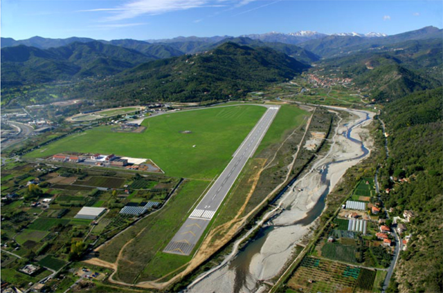
Airport View from East (RWY 27)
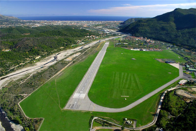
Airport View from West (RWY 09)
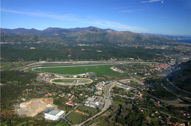
Airport View from South
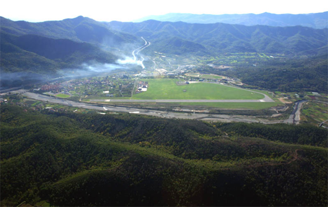
Airport View from North
LIMG – Aerodrome Chart ICAO
1.2. Airspace & Weather Information
LIMG – Aerodrome Chart ICAO
LIMG – Aerodrome Chart ICAO
The airport is located within a Class “G” ATZ with a radius of 3 NM and a vertical limit from GND up to 2,000 ft AGL.
The ATZ is partially inside MILANO TMA (Class “A” airspace).
The Weather Office is the ARO CBO Milano and is open 24H.
The office responsible for TAF preparation is UPM Milano and the TAF has a validity of 9 hours.
NOTE: Use of these information constitute knowledge of official documentation such as AIP ITALIA and NOTAMS
1.3 AFIS
The airport has an AFIS:
Call sign: Albenga Aerodrome INFO
Frequency: 123.850 MHZ
Operating Hours: Summer 06.00Z – 18.00Z / Winter 07.30Z – 17.30Z
NOTE: Use of these information constitute knowledge of official documentation such as AIP ITALIA and NOTAMS
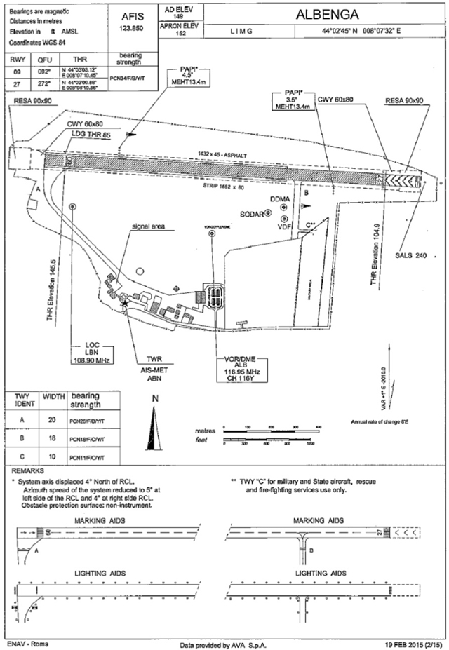
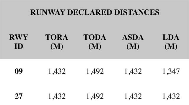
1.4 Runway Information
|
RWY Designation |
QFU |
Dimension (m) |
Strenght and Surface |
|
09 |
092° |
1432 x 45 |
PCN 34/F/B/Y/T ASPH |
|
27 |
272° |
1432 x 45 |
PCN 34/F/B/Y/T ASPH |
|
APPROACH AND RWY LIGHTING |
||||||
|
RWY ID |
Approach Light Type |
THR |
VASIS |
PAPI |
MEHT (m) |
TDZ |
|
09 |
NIL |
THR Green |
NIL |
4.5°(1) Left Side |
13.4 |
NIL |
|
27 |
SALS |
THR Green |
NIL |
3.5° Left Side |
13.4 |
NIL |
(1) In accordance with EU Regulation 965/2012, CAT.POL.A.245, Commercial Air Transport operators shall have an approval for steep approach operations.
NOTE: PAPI RWY 09 system axis is displaced 4° North of the RCL. Azimuth spread of the system is reduced to 5° at the left side of the RCL and 4° at the right side RCL. Obstacle protection surface is Non-Instrument. PAPI usable only following aerodrome circling approach, limited within 4NM ALB
DME and final approach route 4° displaced (RDL 278° VOR ALB). Not usable in the last 500 meters before THR.
NOTE: PAPI RWY 27 system axis is displaced 4° north of the RCL, azimuth spread of the system is reduced to 5° at the left side and 4° at the right side RCL. Obstacle protection surface is Non- Instrumental.
NOTE: Use of these information constitute knowledge of official documentation such as AIP ITALIA and NOTAMS
1.5 Local Traffic Restrictions
Due to the peculiarity of the orography surrounding the aerodrome, in order to avoid interference between instrumental arriving/departing traffic with any other aircraft, no other traffic is allowed on Albenga aerodrome when an IFR departure / arrival is in progress.
Due to the peculiarity of the orography surrounding the aerodrome, in order to avoid interference between instrumental traffic bound to Albenga NDB (ABN) after a balked landing and any other aircraft, no other traffic is allowed in the airspace included between Albenga aerodrome and the holding pattern over Albenga NDB (ABN) when approach and landing is in progress.
Traffic circuit shall always be North of the RWY.
Traffic from / to extra European Union countries and out of Schengen Treaty is allowed every day with a previous request 3 hours before Flight Plan.
All general aviation aircraft movements from / to aprons must be conducted only with Marshall car assistance.
NOTE: Use of these information constitute knowledge of official documentation such as AIP ITALIA and NOTAMS
1.6 Procedures for VFR Flights
In order to facilitate VFR flight operations from/to Albenga airport, outside the ATZ the following visual reporting points are established:
CERIALE (MG-NE1) – suggested altitude for entering aircraft: 1500 ft AGL; suggested altitude for leaving aircraft: 1000 ft AGL
ALASSIO (MG-SE1) – suggested altitude for entering aircraft: 1500 ft AGL; suggested altitude for leaving aircraft: 1000 ft AGL
NOTE: Use of these information constitute knowledge of official documentation such as AIP ITALIA and NOTAMS
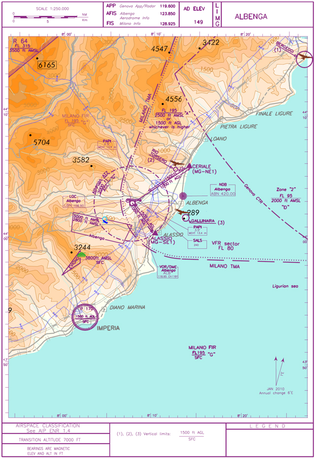
LIMG – Visual Approach Chart
1.7 Training activity
An acrobatic training area is also established over the aerodrome (see AIP ENR 5.5.2).
Lascia un commento